

Arctic Weather Satellite’s First Images Capture Storm Boris
A major leap in weather observation capabilities just a month post-launch.
ESA's Arctic Weather Satellite Captures Stunning Imagery of Storm Boris
).png)
F. Schubert
A humanist first, passionate about human interactions, AI, Space, Human Life and a DJ. 20 year experienced in Team Management in BBAS3 and also founder of Estudio1514.com. São Paulo, Brazil based.


Resumo
Just a month after its launch, the European Space Agency's (ESA) Arctic Weather Satellite has made a significant impact by delivering its first images. Notably, it has been instrumental in capturing the dynamics of Storm Boris, which has caused considerable disruption across central Europe. This satellite is equipped with a state-of-the-art 19-channel cross-track scanning microwave radiometer, allowing it to penetrate the atmosphere and provide detailed temperature and humidity profiles, regardless of weather conditions.
Overview of the Arctic Weather Satellite
Despite its name suggesting a focus solely on the Arctic region, this satellite plays a broader role. It measures temperature and humidity across various altitudes globally. However, its capability to gather humidity data is particularly crucial for forecasting weather in the Arctic, where water vapor levels can fluctuate dramatically. Launched on August 16, this advanced piece of technology is still completing rigorous testing as part of its commissioning phase. On September 14, engineers adjusted the satellite's testing schedule to assess its effectiveness in measuring the impacts of Storm Boris.
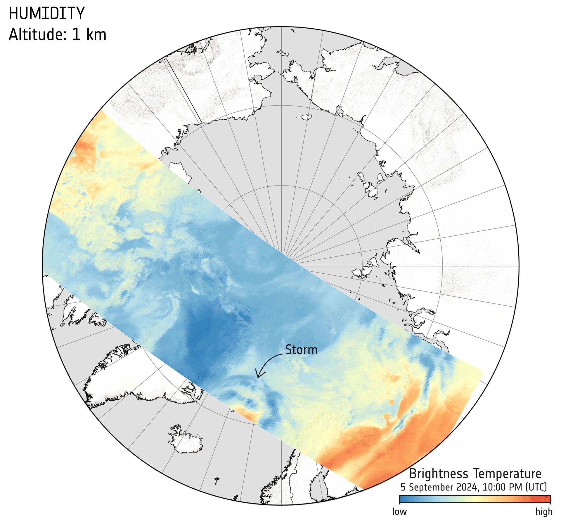
The satellite's observations are represented in terms of "brightness temperature," where lower values—shown in blue—indicate higher humidity levels. The animation generated from this data presents these measurements at 1 km intervals, illustrating the torrential rainfall brought by Storm Boris over Hungary, Slovakia, and Poland. It is a stark reminder of the storm's reach, affecting thousands and extending from Poland to Italy and Romania.

How the Arctic Weather Satellite Works
One of the key features of the Arctic Weather Satellite is its prototype design, which embodies a 'New Space' approach. This methodology emphasizes quick development and relatively low costs, a strategy that could be replicated in future satellite constellations. ESA plans to create a constellation named EPS-Sterna for Eumetsat, aimed at providing more frequent Earth coverage while offering an almost continuous stream of data for short-term weather forecasting, also known as 'nowcasting.' The benefits of such a system during severe storms like Boris are clear and undeniable.
Implications for Weather Forecasting in the Arctic
The importance of this satellite extends beyond mere data collection; it addresses a critical need for improved weather forecasting in the Arctic. This region experiences rapid changes in humidity levels, making timely and accurate data essential. Moreover, climate change impacts are more pronounced in the Arctic compared to other areas, meaning developments here have far-reaching implications for the global climate system.
Another animation released utilizes data from September 5, presenting a broader overview of humidity as brightness temperature. It captures another storm developing over the Arctic, specifically between Greenland and Svalbard, highlighting the satellite's capabilities in assessing atmospheric conditions. The displayed data integrates multiple passes of the satellite over the region throughout the day, significantly enhancing our understanding of the storms' behaviors in high latitudes.
Limitations of Existing Weather Satellites
Current weather satellites positioned in geostationary orbit, such as the Meteosat series, are unable to provide coverage for higher latitudes, thereby limiting their usefulness for Arctic weather forecasting. While the MetOp satellites do return data from polar regions, they may take up to 24 hours to achieve full global coverage, which places constraints on short-term weather forecasting efforts.
The Future of Satellite Observation
As a demonstrator, the Arctic Weather Satellite operates in polar orbit, covering the Arctic similarly to the MetOp satellites. However, the envisioned EPS-Sterna constellation would significantly increase daily observation rates, enhancing not only Arctic coverage but also providing valuable data to regions worldwide. Such advancements will considerably boost weather forecasting accuracy, improve safety, reduce economic losses, and facilitate informed decision-making across vital sectors like agriculture, transportation, and disaster management.
Capturing Unique Weather Events
The third animation derived from data collected on August 27 occurs as the Arctic Weather Satellite's radiometer was activated for the first time. This remarkable event allowed the satellite to capture a storm over Côte d'Ivoire in West Africa. By overlaying measurements from different altitudes on an image of the same storm taken by the first geostationary Meteosat Third Generation Imager satellite, the demonstration showcased the satellite's unique observational abilities.
Ville Kangas, the ESA project manager for the Arctic Weather Satellite, expressed his excitement regarding the initial findings: "Although we are still in the process of commissioning the satellite, these initial results have already exceeded our expectations." He emphasized that even without complete thermal stabilization or fully calibrated parameters, the satellite clearly demonstrates the ability to measure storm dynamics across various altitude layers through cloud and rain, something unattainable with traditional satellite optical or infrared instruments.
Simonetta Cheli, ESA's Director of Earth Observation Programmes, added, "These first results are excellent, and we congratulate everyone involved in developing the satellite, which is already demonstrating that the New Space approach of building such a mission will certainly complement our traditionally-built weather satellites."
Conclusion
The Arctic Weather Satellite's early capabilities are paving the way for a new era in weather observation and forecasting, particularly in challenging environments like the Arctic. With its effective measurement techniques and innovative design, it holds promise for significantly improving how we monitor and respond to climatic changes and extreme weather events around the globe.
